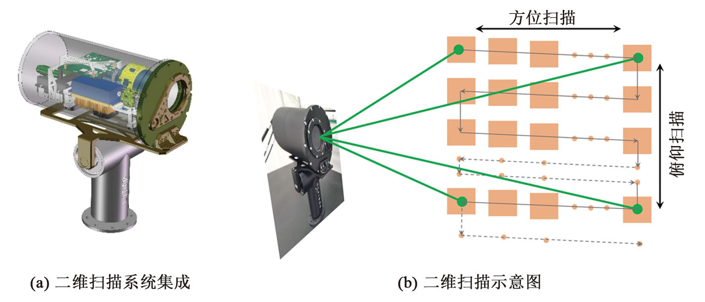
| [1] |
SUN K, CUI W C, CHEN C. Review of underwater sensing technologies and applications[J]. Sensors, 2021, 21(23): 7849. DOI: 10.3390/s21237849.
|
| [2] |
SAHOO A, DWIVEDY S K, ROBI P S. Advancements in the field of autonomous underwater vehicle[J]. Ocean Engineering, 2019, 181: 145-160. DOI: 10.1016/j.oceaneng.2019.04.011.
|
| [3] |
GUMUSAY M U, BAKIRMAN T, TUNEY KIZILKAYA I, et al. A review of seagrass detection, mapping and monitoring applications using acoustic systems[J]. European Journal of Remote Sensing, 2019, 52(1): 1-29. DOI: 10.1080/22797254.2018.1544838.
|
| [4] |
HUY D Q, SADJOLI N, AZAM A B, et al. Object perception in underwater environments: A survey on sensors and sensing methodologies[J]. Ocean Engineering, 2023, 267: 113202. DOI: 10.1016/j.oceaneng.2022.113202.
|
| [5] |
ZHANG J L, XIANG X B, LI W J. Advances in marine intelligent electromagnetic detection system, technology, and applications: A review[J]. IEEE Sensors Journal, 2023, 23(5): 4312-4326. DOI: 10.1109/JSEN.2021.3129286.
|
| [6] |
YU C X, YU Y, WANG Z J, et al. The current state of development in underwater lidar detection[C]// Sixth Conference on Frontiers in Optical Imaging and Technology: Novel Technologies in Optical Systems. Nanjing, China. SPIE, 2024: 51.. DOI: 10.1117/12.3018613.
|
| [7] |
MASSOT-CAMPOS M, OLIVER-CODINA G. Optical sensors and methods for underwater 3D reconstruction[J]. Sensors, 2015, 15(12): 31525-31557. DOI: 10.3390/s151229864.
|
| [8] |
JAFFE J S. Underwater optical imaging: The past, the present, and the prospects[J]. IEEE Journal of Oceanic Engineering, 2015, 40(3): 683-700.
|
| [9] |
HALE J W C, DAVIS D S, SANGER M C. Evaluating the archaeological efficacy of bathymetric LiDAR across oceanographic contexts: A case study from apalachee bay, Florida[J]. Heritage, 2023, 6(2): 928-945. DOI: 10.3390/heritage6020051.
|
| [10] |
吴永江, 李伟, 李博瀚, 等. 基于无人机激光雷达遥感的水下DEM提取研究[J]. 陕西水利, 2025(2):100-102. DOI: 10.23919/OCEANS.2013.6741175.
|
| [11] |
HUA K J, LIU B, FANG L, et al. Detection efficiency for underwater coaxial photon-counting lidar[J]. Applied Optics, 2020, 59(9): 2797-2809. DOI: 10.1364/AO.385592.
|
| [12] |
GUO S C, HE Y, CHEN Y Q, et al. Monte Carlo simulation with experimental research about underwater transmission and imaging of laser[J]. Applied Sciences, 2022, 12(18): 8959. DOI: 10.3390/app12188959.
|
| [13] |
LEE R W, LAUX A, MULLEN L J. Hybrid technique for enhanced optical ranging in turbid water environments[J]. Optical Engineering, 2014, 53(5): 051404. DOI: 10.1117/1.oe.53.5.051404.
|
| [14] |
ZHOU X, QIU C R, SUN J F, et al. Research on triggering properties enhancement of polarization detection geiger-mode APD LIDAR[J]. Journal of Quantitative Spectroscopy and Radiative Transfer, 2020, 254: 107182. DOI: 10.1016/j.jqsrt.2020.107182.
|
| [15] |
GAO C D, ZHAO M L, CAO F Y, et al. Underwater polarization de-scattering imaging based on orthogonal polarization decomposition with low-pass filtering[J]. Optics and Lasers in Engineering, 2023, 170: 107796. DOI: 10.1016/j.optlaseng.2023.107796.
|
| [16] |
MACCARONE A, MCCARTHY A, REN X M, et al. Underwater depth imaging using time-correlated single-photon counting[J]. Optics Express, 2015, 23(26): 33911-33926. DOI: 10.1364/OE.23.033911.
|
| [17] |
PELLEN F, INTES X, OLIVARD P, et al. Determination of sea-water cut-off frequency by backscattering transfer function measurement[J]. Journal of Physics D: Applied Physics, 2000, 33(4): 349-354. DOI: 10.1088/0022-3727/33/4/306.
|
| [18] |
SHANGGUAN M J, YANG Z F, LIN Z F, et al. Compact long-range single-photon underwater lidar with high spatial-temporal resolution[J]. IEEE Geoscience and Remote Sensing Letters, 2023, 20: 1501905. DOI: 10.1109/LGRS.2023.3274449.
|
| [19] |
SHANGGUAN M J, LI Y, MO Y C, et al. Compact underwater single-photon imaging lidar[J]. Optics Letters, 2025, 50(6): 1957. DOI: 10.1364/ol.557195.
|
| [20] |
HUA K J, LIU B, FANG L, et al. Correction of range walk error for underwater photon-counting imaging[J]. Optics Express, 2020, 28(24): 36260-36273. DOI: 10.1364/OE.404539.
|
| [21] |
ZHOU G Q, ZHOU X, LI W H, et al. Development of a lightweight single-band bathymetric LiDAR[J]. Remote Sensing, 2022, 14(22): 5880. DOI: 10.3390/rs14225880.
|
 ), YU Yang1, YE Dingmu1, LI Hui1, CHEN Chao1,2, YU Changxin1