山东科学 ›› 2022, Vol. 35 ›› Issue (5): 122-129.doi: 10.3976/j.issn.1002-4026.2022.05.015

• 环境与生态 • 上一篇    下一篇

基于地理国情数据的河南省沿黄区域自然生态系统分布特征

胡婵娟(), 李双权, 郭雷*(), 杜军, 刘鹏, 任杰   

  1. 河南省科学院 地理研究所,河南 郑州 450052
  • 收稿日期:2021-10-25 出版日期:2022-10-20 发布日期:2022-10-10
  • 通信作者: 郭雷 E-mail:huchanjuan1981@126.com;68404051@126.com
  • 作者简介:胡婵娟(1981—),女,博士,副研究员,研究方向为土壤生态学和景观生态学。E-mail: huchanjuan1981@126.com
  • 基金资助:
    河南省重点研发与推广软科学研究项目(212400410341);河南省科学院基本科研费项目(220601047);河南省科学院2022年度科技智库项目(220701003)

Distribution pattern of natural ecosystems in the Yellow River region in Henan based on national geoinformation data

HU Chan-juan(), LI Shuang-quan, GUO Lei*(), DU Jun, LIU Peng, REN Jie   

  1. Institute of Geographical Sciences, Henan Academy of Sciences, Zhengzhou 450052,China
  • Received:2021-10-25 Online:2022-10-20 Published:2022-10-10
  • Contact: GUO Lei E-mail:huchanjuan1981@126.com;68404051@126.com

摘要:

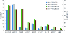
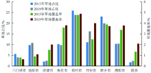
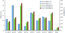
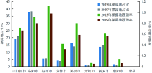
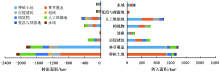
基于地理国情监测数据,分析了河南省沿黄8市1县林地、草地、湿地、裸露地等自然生态系统的分布特征及2015—2019年的地表覆盖变化特征,发现沿黄区域不同自然生态系统中林地、草地、湿地及裸露地表的覆盖率分别为36.12%、2.61%、2.01%和0.56%。林地主要以阔叶林和阔叶灌木林为主,研究期间,针叶林、乔灌混交林、绿化林地和人工幼林面积有所增加,阔叶林与针阔混交灌木林面积有所减少;草地主要以高覆盖度草地为主,占草地面积的81.47%,研究期间,高覆盖度草地、绿化草地和护坡灌草面积有所增加,中覆盖度草地与牧草地面积有所减少;湿地中河流占整个湿地面积的97.63%,河流和水渠面积均呈增加趋势;裸露地以砾石地表为主,占整个裸露地的60%以上,研究期间,不同类型裸露地均呈下降趋势。总体来看,河南省沿黄区域不同自然生态系统分布特征存在差异,林地主要分布在黄河中游河南段区域,草地主要分布在黄河下游河南段区域,湿地空间分布上黄河下游河南段整体上高于黄河中游河南段区域,裸露地空间分布上黄河中游河南段区域整体高于黄河下游河南段区域。林地和裸露地覆盖率整体有所降低,草地和湿地覆盖率整体呈增加趋势。

关键词: 地理国情, 生态系统, 分布格局, 沿黄区域, 地表覆盖, 生态现状

Abstract:

Based on the monitoring data of national geoinformation, this study analyzes the distribution pattern and change characteristics of natural ecosystems, including forest land, grassland, wetland, and bare land, from 2015 to 2019 in eight cities and one county along the Yellow River in Henan Province, China. Results show that the coverage rates of forest land, grassland, wetland, and bare land along the Yellow River are 36.12%, 2.61%, 2.01%, and 0.56%, respectively. Forest land was dominated by broad-leaved forests and broad-leaved shrub forests. The land coverage of coniferous forests, arbor-shrub-mixed forests, afforested land, and artificial young forests increased, and the land coverage of broad-leaved, coniferous, and broad-leaved shrub-mixed forests decreased during the study period. Grassland was dominated by high-coverage grassland, accounting for 81.47% of the grassland area. During the study period, the area of high-coverage grassland, artificial green grassland, and slope-protected shrub grassland increased and the area of medium-coverage grassland and herbage grassland decreased. The wetland was dominated by rivers, occupying 97.63% of the total wetland area. During the study period, the area of rivers and canals increased. The gravel surface was dominant, accounting for >60% of the total bare land. During the study period, the coverage area of all types of bare land showed a downtrend. Overall, in the Yellow River region of Henan Province, the distribution characteristics of different natural ecosystems differed; forest land was mainly distributed in the middle reaches, while the grassland was mainly distributed in the low reaches; the spatial distribution of the wetland area in the low reaches was higher than that in the middle reaches,while the area of bare land in the middle reaches was higher than that in the low reaches. During the study period, the coverage of forest land and bare land decreased, while that of grassland and wetland increased.

Key words: national geoinformation, ecological system, distribution pattern, Yellow River region, land cover, ecological status

中图分类号: 

  • P9